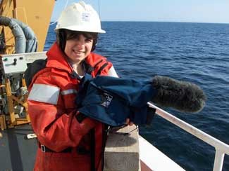
Residents in Nome and farther north in Alaska have witnessed climate change with their own eyes. Thinning ice sheets, fewer gray whales in the region and coastal villages sinking into the sea are telltale signs that the world is warming. But what about the communities of animals below the surface? Scientists aboard the US Coast Guard Icebreaker Healy have just completed a month-long study of the Bering Sea.  Their mission was to gather as much data as possible about the plants and animals in the water. “The main project was looking at what happens to the animals on the bottom as we see the ice recede in the springtime,” said Lee Cooper, one of the chief scientists leading the research cruise entitled, “Climate-driven Changes in Impacts of Benthic Predators in the Northern Bering Sea.” In this case, the benthic predators are walruses, sea ducks, gray whales, seals and crabs that feast on the food living on the seafloor. By monitoring these meals in the mud, researchers hope to better predict how climate change will affect the movement of predatory animals into and out of the Bering Sea. No one has previously investigated this aspect of climate change.
“One of things we’ve been seeing in the last few years is that the ice is leaving about three weeks earlier than before,” said Jackie Grebmeier, the other chief scientist aboard the Healy. “That has an impact because the animals are adapted to a certain timing.” The Bering Sea is one of the most, if not the most, productive oceans on Earth, but Grebmeier and the other scientists onboard have all said they see signs of the system slowing down.
Grebmeier, a researcher at the University of Tennessee, studies the flow of nutrients from the surface to the seafloor. Carbon, for example, is the main component of any diet. It starts at the surface in the form of algae. The algae bloom when the ice melts in the spring. If the timing is off due to an early ice melt, the plants and animals in the water must also adjust so they can get food. Grebmeier’s team is trying to see if who can adjust and who can’t.
Pieces of the Puzzle
Understanding changes in a whole ecosystem, such as the Bering Sea, involves investigating all the angles. Cooper and Grebmeier were joined by a small army of researchers from several universities. Each group was studying a different – but related -- piece of the climate change puzzle.
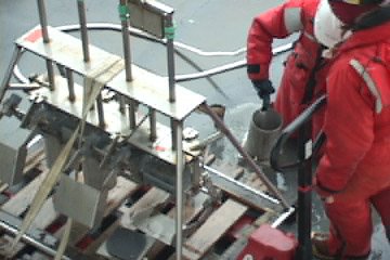
Beth Caissie and Kinuyo Kanamaru from the University of Massachusetts were collecting sediment samples to understand the climate as far back as 20,000 years. They sent down a device that took cylinder-shaped cores of the mud at the bottom.
Grebmeier also used the sediment samples. She set them in a dark, cold room that mimicked conditions on the seafloor and measured how quickly the tiny animals in the mud used up oxygen and gave off carbon dioxide to see how quickly they metabolize food.

Water samples collected at different depths were filtered through several different machines. Marjorie Brooks had one device that captured microscopic algae on thin paper discs. In the coming months, Brooks will analyze the algae in her lab at the University of Wyoming. She is looking for chemical “biomarkers” that she can trace all the way through the food web. “This will link the food web chemically,” said Brooks. “It will help us determine who is eating the algae and which animals are eaten by which predators.”
Brooks is working with Jim Lovvorn, also from the University of Wyoming. Lovvorn has been studying spectacled eiders for many years. These sea ducks dive to the bottom of the Bering Sea, some 50 to 80 meters down, to feed on the clams and other bivalves along the seafloor. But no one knows where these birds go just before they head for their springtime breeding sites farther north. “This is a critical time when females have to maintain and even gain weight before they arrive at breeding areas,” said Lovvorn. He took to the skies in on-board helicopter, but had no luck in locating the spectacled eiders. Their whereabouts remain a mystery.
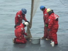
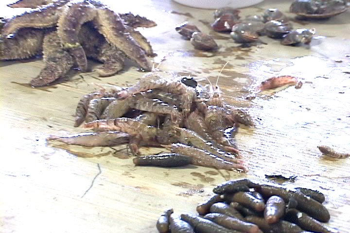
 Less of a mystery, however, is the food available to the diving birds, walruses, whales and seals in the region. Lovvorn’s team did the first trawls in the Bering Sea to build a database of all of the species living at the bottom. Brooks will also trace her biomarkers through these samples to develop a food web model.
Of course, the food web has to begin somewhere. In this case, algae form the foundation for life in the Bering Sea. Karen Frey used the Healy’s satellite system to get snapshots of the sea ice from space. “I’m interested in the timing of when sea ice melts and when we get blooms of plants, or algae, in the water,” said Frey. “How long after the sea ice melts plants start to grow in the ocean?” Frey tracks when the sea ice melts, but she also follows the flow of algae down to the bottom by tracking the amount of chlorophyll (the chemical plants use to convert sunlight into energy) at different depths. “And when it falls to the bottom of the ocean, there are lots of critters down there that love to eat these algae species, so it is a very important time of the year for biological productivity,” she said.
Tying it All Together
So what does all of this research tell us about the Bering Sea? “I think the importance of the results we have found is that the biology and the physics are tied together,” said Grebmeier. “We’re seeing a decline of the prey source and the warming of the temperatures that will have large impacts that are beyond the one study area that we’ve been in.” Those shifts are already pushing whale and walrus populations north. Subsistence hunters have felt this blow. Residents of Gambell failed to catch a whale this year.
The Healy research cruise, supported by the National Science Foundation, ended June 5, 2006, but Cooper said they plan to return next year to continue their work. “It is easy to show that the water has warmed up a few degrees and the ice has pulled back earlier,” he said. “But we’ve shown that under all that ice that things are changing on the bottom, too. The other point is that this is a very special system. As the climate changes, it is possible that the system we have now, with walrus and whales and seals that are associated with ice will be gone and we won’t have a special a place up here anymore.”
 Their mission was to gather as much data as possible about the plants and animals in the water. “The main project was looking at what happens to the animals on the bottom as we see the ice recede in the springtime,” said Lee Cooper, one of the chief scientists leading the research cruise entitled, “Climate-driven Changes in Impacts of Benthic Predators in the
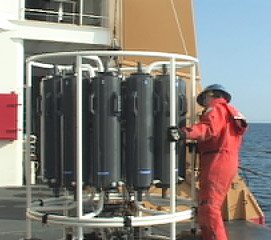
 Less of a mystery, however, is the food available to the diving birds, walruses, whales and seals in the region. Lovvorn’s team did the first trawls in the
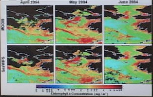 This time series image show chlorophyll in the Bering Sea during spring bloom in 1994. Black indicates no chlorophyll and red indicates lots of chlorophyll. The algae use chlorophyll to convert sunlight into energy during photosynthesis, so a lot of chlorophyll in the water indicates a lot of plant activity. “We’re really only seeing down to about 20 meters, so light’s not penetrating at certain wavelengths much deeper than that,” said Frey. “The phytoplankton in the ocean grow just like any other plant would; they need nutrients and sunlight. If light’s not penetrating deeper, then the phytoplankton aren’t able to photosynthesize at deeper depths because there’s no sunlight available at those depths. But we do see them at those depths. Basically that’s telling us that phytoplankton are forming at the surface and sinking down through of the water column.”
 diatoms and other tiny plants made of silica, the same chemical in glass.