For Bering Sea Ice, Timing is Everything
The engines roared as the Healy’s metal hull plowed into the thick white ice surrounding Big and Little Diomede islands. The ship collided with ice for several meters, swallowing ice chunks under the bow and then retreating to the open water it just created to get back to ramming speed. It seemed like we had made good headway through the ice pack. Yet, a satellite image revealed that the Healy had barely made a dent in the icy blanket around the islands. That made me wonder what else satellites are telling us about the Bering Sea.
“We can actually get real-time satellite imagery of where we are in the Bering Sea,” said Karen Frey, a scientist with the University of Tennessee. “The ship has an antenna mounted right above us, so it downloads data directly from the satellites orbiting the Earth.” Frey is using satellite imagery to track the sea ice in the Bering Sea. She is wants to know when the sea ice melts because that triggers a flurry of activity for the plants and animals in the water. If the melt happens too early, everything living in the Bering Sea has to adjust or move north to find more ice.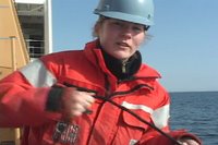
“We can actually get real-time satellite imagery of where we are in the Bering Sea,” said Karen Frey, a scientist with the University of Tennessee. “The ship has an antenna mounted right above us, so it downloads data directly from the satellites orbiting the Earth.” Frey is using satellite imagery to track the sea ice in the Bering Sea. She is wants to know when the sea ice melts because that triggers a flurry of activity for the plants and animals in the water. If the melt happens too early, everything living in the Bering Sea has to adjust or move north to find more ice.

“I’m interested in the timing of when sea ice melts and when we get blooms of plants in the water. How long after the sea ice melts do plants start to grow in the ocean?” Frey explained. The plants she mentioned are not your regular garden variety, unless you are in the Bering Sea. “The general term for them is phytoplankton; it’s basically one-celled algae, like diatoms.” she explained.
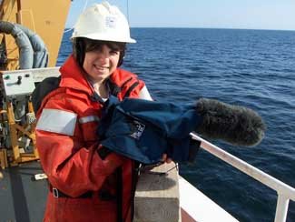
To study the amount and location of this plant life in the water, Frey lowers a device that measures sunlight, temperature and chlorophyll to the seafloor some 30 to 50 meters below.
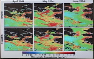 This time series image show chlorophyll in the Bering Sea during spring bloom in 1994. Black indicates no chlorophyll and red indicates lots of chlorophyll. The algae use chlorophyll to convert sunlight into energy during photosynthesis, so a lot of chlorophyll in the water indicates a lot of plant activity. “We’re really only seeing down to about 20 meters, so light’s not penetrating at certain wavelengths much deeper than that,” said Frey. “The phytoplankton in the ocean grow just like any other plant would; they need nutrients and sunlight. If light’s not penetrating deeper, then the phytoplankton aren’t able to photosynthesize at deeper depths because there’s no sunlight available at those depths. But we do see them at those depths. Basically that’s telling us that phytoplankton are forming at the surface and sinking down through of the water column.”
Sinking phytoplankton means a smorgasbord of seafood is on the way for the animals that live on the seafloor. Clams, sea cucumbers, shrimp-like amphipods and more gobble up the plants that drop to the bottom. In turn, walruses, seals and sea ducks dive to the seafloor to feast on those plant-eaters in the mud. Finally, local hunters from the islands rely on the walruses, seals and birds for food.
The trouble is, Frey and her colleagues aboard the Healy are seeing the springtime blooms earlier as the sea ice is starting to melt sooner than expected. “We’ve seen that spring is coming earlier and earlier every year. So not only are we seeing warming temperatures as a whole, but the timing of all of the things happening throughout the seasonal cycle is getting earlier,” she said. “That’s a problem for the animals that live here. We’ve seen northward movement of a lot of species.” The animals move north where the temperatures are colder, and the ice melts when they expect it to melt.” The image below shows a thick ice cover (red) north of the Bering Strait and a band of thin ice (blue) outlining the edges of Russia and Alaska. The large black portion in the lower left is open ocean.

“One of the reasons that Arctic stays cool is that we have all of these really bright reflective surfaces, really white colored surfaces like ice and snow,” explained Frey. “Once you start melting this ice and snow, you’re replacing really bright surfaces with very dark surfaces, like the ocean. The ocean is actually a very good absorber of sunlight. And when you’re a good absorber of sunlight, you actually warm the air temperatures even more.” Scientists call this trend the positive ice-albedo feedback loop. Once it starts, the whole systems “snowballs” into warmer and warmer temperatures.
“The Arctic specifically as a region is so much more susceptible to warming than anywhere else because of the ice-albedo feedback loops,” said Frey. Researchers say the five most extreme seasons have taken place in the last decade. “We’re seeing warming here more pronounced and earlier than anywhere else on Earth.” Researchers say in time, maybe not much time, we’ll see major changes taking place.
posted by Karen de Seve at 9:03 AM
![]()
![]()

<< Home